


Rocklogger
Rocklogger의 설명
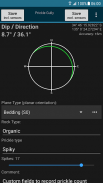
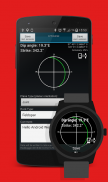
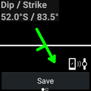
Rocklogger is a geological tool for measuring the orientation of rock outcrops. It uses the phone's compass and orientation sensors to measure dip & dip direction, or dip & strike, in a single click.
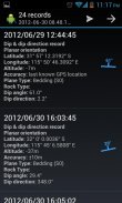
GPS and magnetic field information can also be saved, along with details on the rock plane & type.
Key features:
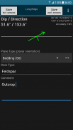
-Log dip & strike or dip & dip direction by placing the phone on the rock/plane in any orientation (using the rotating symbol and quick help features as guides)
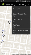
-Plot logs on a map, with correct dip/strike symbols
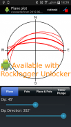
-Plot poles or planes from logs on a stereonet, and interpret by touching the plot to find trends and intersections (paid only)
-Log the ambient magnetic field
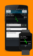
-Launch the camera to take photos while logging. Notes and GPS data are saved to the log file. Photos are stored with the log file, and are automatically attached when you send a log via email from the browser screen
The log is saved to a .csv file, which can be sent to Excel / Mapinfo / etc for interpreting. Paid versions can also export KML files for use in Google Earth (Android or desktop version).
Taking the strike and dip of outcrops with a compass / declinometer usually takes a few minutes per rock. With Rocklogger, many measurements of an outcrop can be taken in seconds (in any orientation). It also works upside-down, eg for logging overhang in a mine.
The evaluation version is limited to saving 3 records per 3 minutes, and has the stereonet plotter disabled. Rocklogger Unlocker is available for purchase to disable the evaluation version restrictions.Rocklogger 바위 노두의 방향을 측정하는 지질 학적 도구입니다. 그것은 한 번의 클릭으로, 딥 & 딥 방향, 또는 딥 & 파업을 측정하기 위해 휴대 전화의 나침반 및 방향 센서를 사용합니다.
GPS 및 자기장 정보는 바위면 및 유형에 대한 상세 정보와 함께 저장할 수 있습니다.
주요 특징 :
로그 딥 & (가이드로 회전 기호와 빠른 도움말 기능을 사용하여) 어떤 방향으로 바위 / 비행기에 전화를 배치하여 파업 또는 딥 & 딥 방향
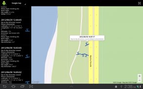
음모는 올바른 딥 / 파업 기호,지도에 기록
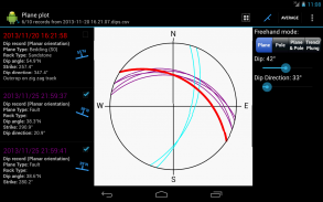
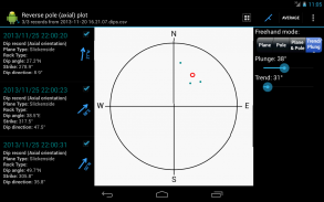
플롯 극 또는 비행기 stereonet에 로그에서, 그리고 (만 지불) 동향 및 교차로를 찾기 위해 음모를 터치하여 해석
주위의 자기장에게 로그
로그인 할 때 사진을 찍어 카메라를 발사. 노트 및 GPS 데이터는 로그 파일에 저장됩니다. 사진은 로그 파일에 저장되며, 사용자가 브라우저 화면에서 이메일을 통해 로그를 보낼 때 자동으로 연결되어
로그는 해석 엑셀 / MAPINFO / 등으로 보낼 수 있습니다. csv 파일에 저장됩니다. 유료 버전은 또한 구글 어스 (안드로이드 또는 데스크톱 버전)에서 사용할 KML 파일을 내보낼 수 있습니다.
나침반 / 방위 각계와 노두의 파업과 수영을 복용하는 것은 일반적으로 바위에 몇 분 정도 걸립니다. Rocklogger으로, 노출의 많은 측정 (어떤 방향으로) 초 단위로 촬영 할 수 있습니다. 또한 광산에서 로깅 오버행에 대한 예를 들어 거꾸로, 작동합니다.
평가 버전 3 분당 3 레코드를 저장하기에 제한되어 stereonet 플로터가 비활성화되었습니다. Rocklogger의 Unlocker는 평가 버전 제한을 해제하는 구입할 수 있습니다.
Rocklogger - 버전 2.0
(22-02-2018)Rocklogger - APK 정보
APK 버전: 2.0패키지: com.rockgecko.dipsRocklogger의 최신 버전
다른 버전들


 4.11
4.11


 3.89
3.89동일 카테고리의 앱

좋아할 만한 것...

 3.724.073.612.654.11


